Main Menu | Jersey Shore Real Estate | Jersey City / Hoboken Real Estate | Hudson County Politics | Hudson County Facts | New Jersey Mafia | Email this Page
Reset Windows XP or Vista Passwords | Reinstalling Windows XP | eMachine Power Supplies are a TIME BOMB! | Computer Noise | Don't Trust External Hard Drives!
Advertise Online Charlie Tarzian, CoActive Marketing Group CEO CMKG Stock Rates Strong Buy! Nationwide Promo Model Jobs NJ Bicycle Routes La Cosa Nostra The Malcontent

From Historic Roadsides of New Jersey by The Society of Colonial Wars in the State of New Jersey, 1928
Edited by GET NJ, COPYRIGHT 2002

CAMDEN COUNTY

Camden County, originally part of old Gloucester, was organized under an Act passed by the Legislature March 13, 1844. Long. a. Coming (Berlin) was the first County Seat, but in 1848 at a fourth election held to vote on a County Seat, Camden won a majority and is now the seat of the county government. The County was named, as is the City, after Charles Pratt, Earl of Camden, a great Judge, a wise States. man and warm advocate of fair play for the Colonies. The County is bounded on the northeast by Burlington; on the southeast by Atlantic: on the southwest by Gloucester and on the northwest by the Delaware River.

CAMDEN
Originally styled "Pyne Poynte" and later Cooper's Ferry, was settled in 1681 by Richard Arnold and William Cooper, who built on the River's edge below the mouth of Deer Creek. He had a deed from the Proprietors of West Jersey, but also bought the land from the Indians, obtaining a deed executed by Tolacca, Chief of the Tribe. His second house was above Cooper's Point called by him Pyne Point, and is still standing. A ferry to Philadelphia was established near the foot of Cooper Street by the County and a license to operate it was granted to William Royden. It was bought from Royden by Cooper and the settlement became known as Cooper's Ferry. The ferry over Cooper's Creek was established, at what is now Federal Street, in 1747 by Samuel Spicer.

Kaighn's Point, was settled by John Kaighn in 1696, and land lower down the River was bought by Archibald Mickle, who, with Cooper and Kaighn, owned practically all of Cam. den between Cooper's Creek and the Delaware. 
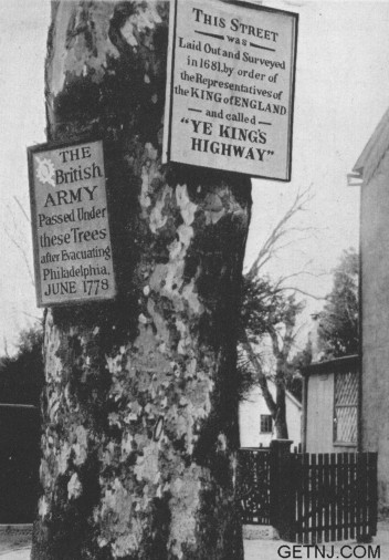
In February of 1778, General Wayne forced the British to take shelter behind the works at Cooper's Point and on March 1, 1778, a spirited skirmish took place between Sixth and Market Streets and Cooper's Creek Bridge, Count Pulaski distinguishing himself.

In June of 1777, the Trustees of Princeton College held a meeting at Cooper's Ferry and granted degrees to the Class of '76, the only meeting of the Trustees held out of Princeton because of the War.

The first Charter was granted to Camden in 1828. The Camden and Amboy Railroad was chartered in 1830, and the first train ran into Camden January, 1834.

Points of interest:

  1. 1128,30 S. Second Street. Southeast corner of Second and Sycamore Streets. House of John Kaighn, founder of Kaighn's Point.
  2. Point Street House. At head of Point Street, bearing date 1734, headquarters of General Abercrombie, British Com. mander in the Revolution.
  3. Cooper Park. Elm tree grown from a sucker from the Penn Treaty Elm in Philadelphia.
  4. Mt. Ephraim Avenue and Mt. Vernon Street. Friends Meeting House built 1801.
  5. Champion Road. West Collingswood Railroad Station site of home of Mark Newbie, authorized by Act of Assembly of 1682 to circulate "Mark Newbie's half pence," also called "Patrick's half pence," on giving security for redemption.
  6. South side of Cooper Street, near Friends Avenue, site of home of the Naturalist, John James Audubon.
  7. 328 Mickle Street. Home of Walt Whitman.
  8. Harleigh Cemetery. Tomb of Walt Whitman.
  9. Cooper House at Pyne Poynte.
The Indian King Tavern, Haddonfield

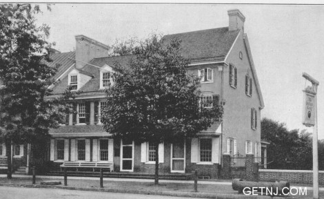
HADDONFIELD
On Cooper's Creek about five miles south. east of Camden. The place takes its name from the family of John Haddon, who purchased the land on which the town is built about 1710. His daughter, Elizabeth Haddon, came to New Jersey from England and built a brick residence about 1713, later referred to. Haddonfield, although inhabited by Quakers, was successively occupied by American and British Troops and was the scene of a number of skirmishes.

Points of interest:
  1. The Indian King Tavern. Built 1750. Meeting place of State Legislature in 1777, where the great Seal of the State was received and adopted. Building owned by State and managed by a commission. Marked by a tablet erected by Daughters of American Revolution.
  2. Opposite Indian King, on Kings Highway, is the building used as a guardhouse during Revolution. This guardhouse was on the premises of William Griscomb.
  3. Kings Highway and Haddon Avenue. Buttonwood trees dating to the Revolution marked by tablet.
  4. Friends Meeting House first built 1720. Present meeting house built 1760 on same site.
  5. Estaugh. Site of house of Elizabeth Haddon on road to Camden. Present house built 1842 on foundation of original house. The still or brew house of Elizabeth Had. don still exists, also a yew tree brought from England in 1713 and a box hedge. On the present house, on the side door, is to be found the brass knocker of the original house of Elizabeth Haddon.
  6. Memory of Elizabeth Haddon commemorated by tablet placed on buttonwood tree in Orthodox Friends Graveyard.
Buttonwood Tree, Haddonfield

Return To
The Historic Roadsides in New Jersey
Table of Contents

Hudson County Facts  by Anthony Olszewski - Hudson County History
Print Edition Now on Sale at Amazon

Read Online at
Google Book Search

Order a Copy by Mail
Send $3 to:
Anthony Olszewski
P.O. Box 3362
Jersey City, NJ 07303

Advertiser and Distributor
Inquiries Welcome

Jersey City Garden Post Card (196 Ogden Ave., original, not mailed) – $4.00
Mail your check to Anthony Olszewski, P.O. Box 3362, Jersey City, N.J., 07303
To pay by PayPal, e-mail info@cityofjerseycity.org

The Hudson River Is Jersey City's Arena For Water Sports!

Questions? Need more information? Contact us at:

GET NJ
P.O. Box 3362
Jersey City, NJ 07303

getnj@getnj.com